Saturday 6 October 2012

Vauxhall Nine Elms Battersea Planning Framework

 Vauxhall Nine Elms Battersea as part of the The London Plan

The London Plan identifies Opportunity Areas across the capital, identifying them as places in London with the potential to accommodate substantial numbers of new jobs and homes. Vauxhall Nine Elms Battersea is such an area. 

Published on March 2012,  The Vauxhall Nine Elms Battersea Planning Framework aims to deliver the following vision:


‘A new London quarter for the benefit of the whole community’


By 2030 the 195 hectares of the Vauxhall Nine Elms Battersea Opportunity Area will become an exemplar and distinctive quarter of central London. As an integral part of the London offer, defined by Lambeth Bridge through Vauxhall to Battersea Power Station and Chelsea Bridge, high quality buildings and public spaces will provide opportunities for jobs and the choice of a variety of homes. New cultural and leisure development in this Thames River front location, supported by high quality services, especially public transport, will make this a successful and sustainable place where people will want to be.

Key principles of the framework:
  • Recognising the scale of the development opportunity in central London
  • Overcoming historic and strategic barriers to the delivery of regeneration
  • Setting out a co-ordinated spatial plan for the area which addresses the delivery of new infrastructure and how it will be paid for
  • To realise the optimum development potential of the area with 16,000 newhomes and 20,000 – 25,000 new jobs
  • To establish growth poles in the form of new CAZ (central activity zone) frontages at Battersea PowerStation and Vauxhall
  • To deliver a new mixed use residential neighbourhood and linear park in the heart of Nine Elms
  • To deliver a step change in public transport provision including a twostationextension of the Northern linefrom Kennington to Battersea Power Station with an intermediate station at Nine Elms, supported by a package of rail, bus, cycling, pedestrian and highway improvements
  • To deliver new open space, including a linear park, improved riverside walk and a high quality public realm
  • To create a sustainable place with new social infrastructure, a district heatnetwork, utilities infrastructure andstrategic flood mitigation measures.


The diagram above identifies opportunities to improve existing routes and deliver new routes through the delivery of a series of strategic river links that run north to south across the site. Achieving public access through the railway viaduct and New Covent Garden Market where none exists at present will be key to unlocking north-south permeability.


Personally, this north south permeability is vital to our project - the river should be used to reinforce this concept.


Friday 5 October 2012

Approach to "Sustainable Cities"


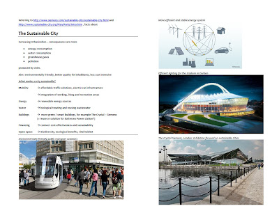
In the Context of the TED-video I collected some basic information about "The sustainable City" - especially "The Crystal - Siemens" might be interesting in terms of getting ideas, knowledge and inspiration.

【HOPE】Greeting Gard

Hmmm...

Hi,

   It's GreenTeam 03, a 1+2+3 group.

   Do you know who are they?


Just for fun!  ^o^

Good night!~~~ZZzzz ZZzzz

Maybe is...
Good morning!~~~


【HOPE】UDP _1st Week_Collection

Hmmm...0_0

Hi...^.^

See below...


Wednesday 3 October 2012

Waterfront developments

 Waterfront Developments - 'Designing Permeability'


How can we integrate the the Thames waterfront with the Battersea site?  This was one of the debates the team had today... moreover, it was agreed that permeability of the land in relationships to the river is a key concept to explore.  How do we integrate the river and land in a meaningful way?  Can we design permeability? Examples of good developments:


Toronto Central Waterfront - West 8
The Central Waterfront extends along 3.5 km along Lake Ontario and in direct proximity to the downtown business district.


The Primary Waterfront – a continuous water’s edge promenade, with a series of pedestrian bridges;  the Secondary Waterfront – a recalibrated Queens Quay Boulevard with a new urban promenade and public spaces at the heads-of-slips; the Floating Waterfront – a series of floating elements that offer new boat moorings and public spaces in relation to the lake, and; the Cultures of the City – connections from Toronto’s diverse neighbourhoods towards the waterfront.


The Central Waterfront extends along 3.5 km along Lake Ontario and in direct proximity to the downtown business district. It is one of Toronto’s most valuable assets, yet, despite decades of planning and patchwork development projects, there was no coherent vision for linking the pieces into a greater whole – visually or physically.  In this context, the fundamental objective of the project was to address this deficiency by creating a consistent and legible image for the Central Waterfront, in both architectural and functional terms.

In Battersea, the Power Station is the most valuable cultural asset, set within a mixed cultural and social landscape (Victoria, Battersea and Nine Elms).  Our design process should look to developing a similar coherent vision for linking and spaces, while maximizing the most valuable assets in the landscape (power station and river).

http://www.west8.nl/projects/toronto_central_waterfront/


Initial Response

Some initial thoughts from, Anna.  The following pages capture some of the thoughts following the site visit on 1st October.


Tuesday 2 October 2012

The Survey Begins... Site Orientation.


Site orientation - October 1st

The Site:
Battersea Power Station and Nine Elms + Extension to Victoria Station 

This project is about making landscape design proposals for Battersea Power Station with a 'meaningful' response to the riverside.